Curious about what makes the culinary culture of Tuzluca, Iğdır so special? In this 2026 gastronomy and local flavor guide, we explore 6 officially registered geographical indication delicacies alongside 6 iconic cultural and sightseeing stops you should experience during your visit.
Quick Highlights & Discovery Route in Tuzluca, Iğdır
- Iğdır Taş Meatball Dinner
- Iğdır Bozbaş Dinner
- Iğdır Omaç Vaccine Soup
- Iğdır White Grape / Miskalı
- Iğdır Eggplant Jam
- Iğdır Apricot
- Tuzluca Rainbow Hills
- Tuzluca Historical Salt Caves and Therapy Center
- Historical Gaziler (Köroğlu) Castle and Aras Strait
Shopping, Traditional Bazaars & Local Markets Guide in Tuzluca, Iğdır
Exploring Tuzluca, Iğdır (Iğdır) offers a rich shopping experience that blends modern retail avenues with centuries-old Anatolian bazaar traditions (Ahilik culture). Whether you are looking for contemporary shopping centers, bustling weekly neighborhood farmers' markets (Semt Pazarları), or authentic handmade crafts, Tuzluca, Iğdır caters to every visitor.
In the local markets and artisan workshops of Tuzluca, Iğdır, visitors can buy farm-fresh seasonal produce, sun-dried herbs, natural olive oil soaps, handwoven textiles, and officially registered geographical indication delicacies of Iğdır directly from local producers.
- Weekly Neighborhood Markets (Semt Pazarları): Visit early in the morning for the freshest village cheeses, organic fruits, mountain honey, and homemade preserves.
- Traditional Bazaars & Artisan Shops: Explore the central commercial streets of Tuzluca, Iğdır for copperware, traditional textiles, ceramics, and authentic regional souvenirs.
- Local Culinary Gifts: Don't leave without packing vacuum-sealed regional spices, roasted nuts, Turkish delight, and registered local specialties of Iğdır.
What to Eat in Tuzluca, Iğdır? Registered Local Delicacies & Gastronomy
A trip to Tuzluca, Iğdır is incomplete without tasting its officially registered geographical indication products and centuries-old Anatolian recipes:
1. Iğdır Taş Meatball Dinner (Yemekler ve çorbalar)

Iğdır Stone Meatball Meal is a geographically indicated value specific to the Iğdır region, registered by the Turkish Patent and Trademark Office on 14.12.2017 (with registration number 276).
View Official Geographical Indication Dossier for Iğdır Taş Meatball Dinner →
2. Iğdır Bozbaş Dinner (Yemekler ve çorbalar)
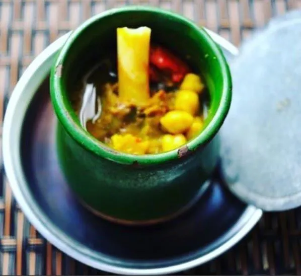
A dish cooked with lamb shank meat, chickpeas, tail fat and yellow root (turmeric) in special earthenware casseroles (piti pot).
History: A centuries-old Caucasian banquet dish in which lavash is chopped into water and the meat is crushed with a mallet and eaten.
View Official Geographical Indication Dossier for Iğdır Bozbaş Dinner →
3. Iğdır Omaç Vaccine Soup (Yemekler ve çorbalar)
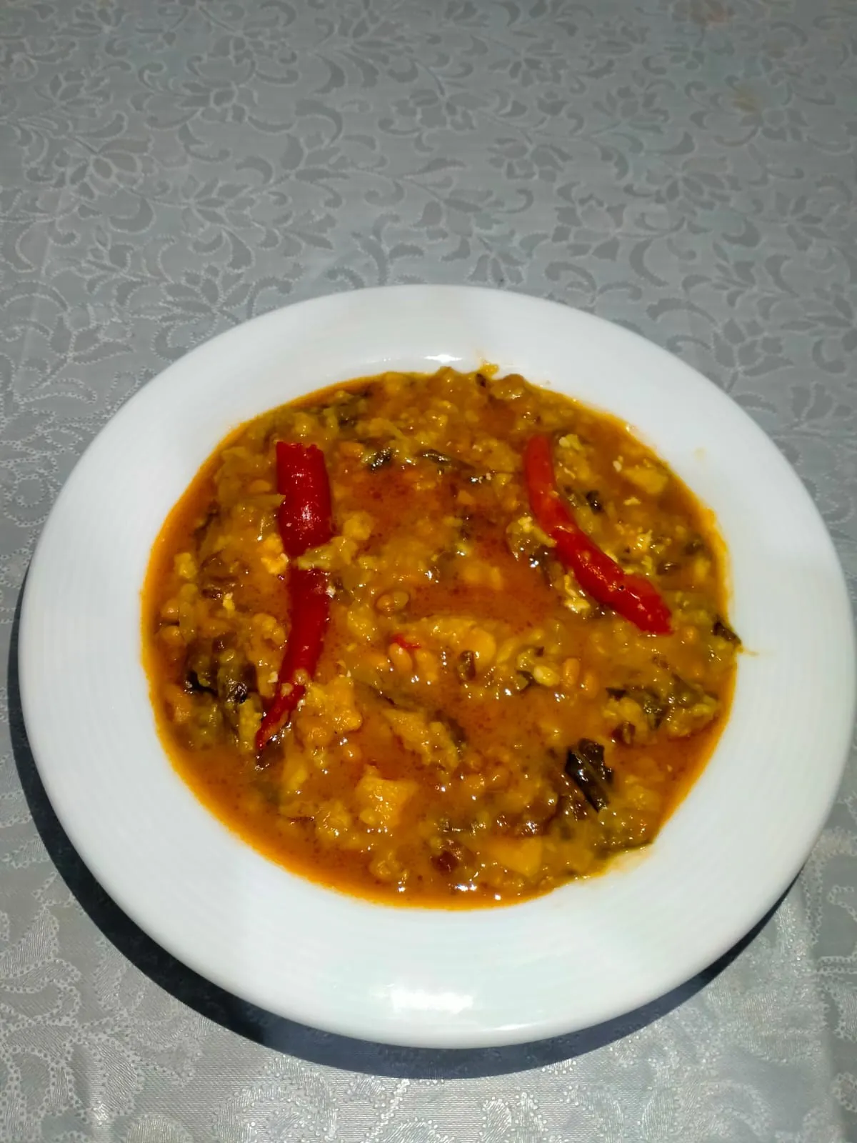
Iğdır Omaç Vaccine Soup is a geographically indicated value of ours, unique to the Iğdır region and registered by the Turkish Patent and Trademark Office on 26.08.2021 (with registration number 876).
View Official Geographical Indication Dossier for Iğdır Omaç Vaccine Soup →
4. Iğdır White Grape / Miskalı (İşlenmiş ve işlenmemiş meyve ve sebzeler ile mantarlar)
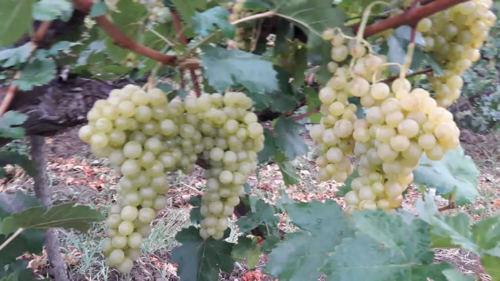
Iğdır White Grape / Miskalı is a geographically indicated value of ours, unique to the Iğdır region and registered by the Turkish Patent and Trademark Office on 09.08.2021 (with registration number 829).
View Official Geographical Indication Dossier for Iğdır White Grape / Miskalı →
5. Iğdır Eggplant Jam (İşlenmiş ve işlenmemiş meyve ve sebzeler ile mantarlar)
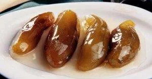
Iğdır Eggplant Jam is a geographically indicated value of ours, unique to the Iğdır region and registered by the Turkish Patent and Trademark Office on 20.12.2021 (with registration number 975).
View Official Geographical Indication Dossier for Iğdır Eggplant Jam →
6. Iğdır Apricot (İşlenmiş ve işlenmemiş meyve ve sebzeler ile mantarlar)
Registered fresh apricot, ripe early in the Aras Valley sun, for table use, oval shaped, red cheeked, sweet and fragrant.
History: Heritage of Aras Valley apricot gardens on the Silk Road.
View Official Geographical Indication Dossier for Iğdır Apricot →
Top Verified Shopping & Historic Bazaars & Must-See Landmarks in Tuzluca, Iğdır
1. Tuzluca Rainbow Hills
Free Public Access • GPS: 40.0733, 43.6630
History and General Information / Local Legends and Folklore
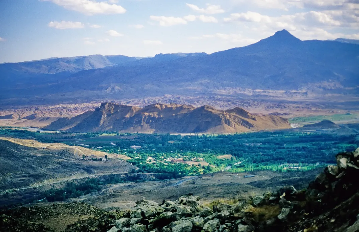
Tuzluca Rainbow Hills is a supernatural geological picture that was formed millions of years ago during the Miocene and Pliocene periods as a result of different mineral, iron oxide, manganese and lime sediments being layered on top of each other and eroded by wind and water. These hills resemble the Vinicunca hills in Peru and the Zhangye Danxia hills in China; It offers a dazzling riot of colors in which red, brown, yellow, orange, white and gray color tones curl into horizontal stripes. Local legend tells that the rainbow in the sky comes down to the earth, rests on these hills of Tuzluca and leaves its colors on the ground.
Geographical Structure, Altitude and Natural Features
It is located on the slopes of the Aras Valley, at an altitude of approximately 950 to 1,200 meters. The undulating badlands topography, consisting of barren clay, gypsum and sandstone layers, prevails.
Visiting Hours, Days and Entrance Fees
- Entrance Fee: Visiting the hills and viewing areas is completely free.
- Visiting Hours and Days: It can be visited freely in daylight, 7 days a week.
- Rules, Safety and Stroller/Disabled Access: Clay slopes can be slippery and sticky on wet days; Non-slip sports shoes should be worn. Viewpoints can be seen from the roadside; The paths are not suitable for strollers.
- Facilities and Facilities: There are vehicle parking areas and viewing areas on the side of the highway.
Transportation, Public Transit Routes and Exact Location
- Address / Open Location: On Iğdır-Kars Highway, Tuzluca / Iğdır.
- Road Condition and Vehicle Availability: It is 5 km away from Tuzluca town centre; passes right next to the hills along the main asphalt highway; It can be reached by all kinds of passenger vehicles.
- Real Public Transportation Information: All buses and minibuses operating between Iğdır-Kağızman-Kars pass through the Gökkuşağı Hills route.
- Parking Availability: Parking can be done in large free viewing pockets on the side of the road.
Contextual Experience Tips, Photography and Local Gastronomy
- Best Photo Spots and Frames: Wide-angle shots and drone shots, where colorful mineral strips wave from the roadside ridge to the horizon.
- Light and Shooting Hours: The golden hours before sunset and morning light, when the sun makes mineral colors most vivid.
- Local Gastronomy Recommendations: Fresh tandoori bread and local cheeses in Tuzluca center after the trip.
Explore Full 5-Section Guide & Map for Tuzluca Rainbow Hills →
2. Tuzluca Historical Salt Caves and Therapy Center

Ticketed / MuseumPass Check • GPS: 40.0511, 43.6661
History and General Information / Local Legends and Folklore
Tuzluca Historical Salt Caves is a huge underground salt city of 55 acres, whose roots date back to the Hittite period and where rock salt has been extracted uninterruptedly for thousands of years. The cave offers a fascinating atmosphere with its giant underground tunnels extending for kilometers, salt columns and illuminated galleries; Today, it is Türkiye's most important "halotherapy" (salt therapy) health tourism center. It has been proven that cave air provides natural healing for asthma, bronchitis, COPD and respiratory diseases, thanks to its content of microscopic salt ions. According to local legend, it is said that these salt galleries were the first salt deposits discovered by the Prophet Noah after the Flood and that they added abundance to the tables.
Geographical Structure, Altitude and Natural Features
It is located within the Tuzluca mountain mass, at an altitude of approximately 1,050 meters. It consists of layers of white and crystallized rock salt with 99 percent purity; The underground temperature is a constant 16 degrees in summer and winter.
Visiting Hours, Days and Entrance Fees
- Entrance Fee: District Governorship and Special Provincial Administration are subject to symbolic ticket tariff (is_free: false).
- Visiting Hours and Days: It is open to visitors 7 days a week between 08:30 - 18:00.
- Rules, Safety and Baby Stroller/Disabled Access: Since it is slightly cool inside the cave, a cardigan should be taken according to the season; It should not be run in galleries. The main galleries are completely flat and covered with asphalt/wood and are very accessible for strollers and disabled chairs.
- Facilities and Facilities: There is an underground conference hall, salt therapy rest rooms, cafeteria, gift salt lamp section, WC and ample parking.
Transportation, Public Transit Routes and Exact Location
- Address / Open Location: Tuzluca District Exit, Kars Road 1st km, Tuzluca / Iğdır.
- Road Condition and Vehicle Availability: It is 1 km from Tuzluca town centre, 40 km from Iğdır city centre, and 85 km from Kars; It is next to the main highway and can be easily reached by any vehicle.
- Real Public Transportation Information: Iğdır-Kars and Iğdır-Tuzluca minibuses drop off directly at the cave entrance.
- Parking Availability: There is a large free parking area in front of the cave entrance.
Contextual Experience Tips, Photography and Local Gastronomy
- Best Photo Spots and Frames: The perspective depth of giant salt pillars illuminated with colored lights and the shimmer of crystal rock salt walls.
- Light and Shooting Hours: Constant underground artistic lighting is available at all hours of the day.
- Local Gastronomy Recommendations: Tea at the cave cafe and Iğdır kete and honey at the Tuzluca exit.
Explore Full 5-Section Guide & Map for Tuzluca Historical Salt Caves and Therapy Center →
3. Historical Gaziler (Köroğlu) Castle and Aras Strait
Free Public Access • GPS: 40.1175, 43.6525
Historical Gaziler (Köroğlu) Castle and Aras Strait
History and General Information / Local Legends and Folklore
- The castle, built on a steep rocky ridge overlooking the Aras River gorge, near Gaziler (formerly Pernavut) Village, 27 km west of Tuzluca district centre, has been a strategic defense fortress since the Bronze Age and Iron Age.
- The building, which is known as the castle of the epic hero Köroğlu in folk narratives, has become legendary as the shelter of brave men and border veterans who went to the mountains against injustice.
- The city walls and rock-carved cisterns that watch over the deep canyon passage of the Aras River have survived to the present day.
Geographical Structure, Altitude and Natural Features
- It is built on a steep limestone cliff with an altitude of 1,050 meters.
- The Aras River flows gurgling from the canyon floor; The slopes are covered with juniper and wild almond bushes.
Visiting Hours, Days and Entrance Fees
- Entrance Fee: It is a historical site and the visit is completely free.
- Visiting Hours and Days: It can be visited in daylight 7 days a week.
- Rules and Safety: You should walk carefully on cliff edges and choose non-slip shoes.
- Facilities and Facilities: There is a village fountain and a grocery store in Gaziler village.
Transportation, Public Transit Routes and Exact Location
- Address / Open Location: Gaziler Köyü Kale Mevkii, 76950 Tuzluca / Iğdır.
- Road Condition: It is located on the 27th kilometer of the Tuzluca-Kars highway; It can be easily reached by passenger vehicles via asphalt highway.
- Real Public Transportation Information: Transportation is possible with Gaziler village minibuses departing from Tuzluca.
- Parking Availability: There is an open parking space for 15 vehicles on the roadside at the foot of the castle.
Contextual Experience Tips, Photography and Local Gastronomy
- The deep canyon cleft of the Aras Strait and the railway bridge from the rock bastions of the castle offer wonderful documentary shots.
- You should taste the mountain thyme tea and oven kete brewed over a wood fire in Gaziler village.
Explore Full 5-Section Guide & Map for Historical Gaziler (Köroğlu) Castle and Aras Strait →
4. Historical Tekelti Mountain and Castle
Free Public Access • GPS: 40.0315, 43.5519
History and General Information / Local Legends and Folklore
Tekelti Mountain (2,560 m) is a volcanic natural monument that rises alone in the middle of the Iğdır Plain, like a giant dog tooth or pyramid stuck in the sky. At its summit, there are historical castle ruins, watchtowers and rock cisterns from the Urartian and medieval Bagratid period. With its steep and steep walls, it is one of the most popular climbing walls in Türkiye for mountaineering and rock climbing enthusiasts. Local legend tells that Mount Tekelti was a huge piece of rock that broke off from Mount Ararat during Noah's Flood, and that the castle at its peak guarded the caravan routes for centuries.
Geographical Structure, Altitude and Natural Features
It is a monolithic volcanic neck formation with a peak altitude of 2,560 meters. It is surrounded by bare steep andesite cliffs and valley steppes.
Visiting Hours, Days and Entrance Fees
- Entrance Fee: Visiting the mountain and castle foothills is completely free.
- Visiting Hours and Days: It can be visited in daylight 7 days a week; Peak climbing is suitable for experienced climbers in the summer months.
- Rules, Safety and Stroller/Disabled Access: Mountain climbing requires professional rock climbing equipment; Sturdy shoes should be worn for walking in the foothills. The mountain terrain is not stroller or disabled accessible.
- Facilities and Facilities: There are natural climbing routes and break areas on the foothills.
Transportation, Public Transit Routes and Exact Location
- Address / Open Location: Tekelti Köyü Mevkii, Tuzluca / Iğdır.
- Road Condition and Vehicle Availability: It is 12 km away from Tuzluca center; It can be reached by passenger vehicle up to the foothills via the stabilized mountain road.
- Real Public Transportation Information: You can reach the foot of the mountain with the village shuttles departing from Tuzluca center.
- Parking Availability: There is a free parking area at the entrance of the village at the foothills.
Contextual Experience Tips, Photography and Local Gastronomy
- Best Photography Spots and Frames: Wide angle compositions of the pointed pyramidal silhouette of Tekelti Mountain stretching straight into the sky from the Aras Valley.
- Light and Shooting Times: The first sunlight hitting the sharp peak of the mountain in the early morning hours and the sunset silhouette.
- Local Gastronomy Recommendations: Freshly milked milk cream in the village, tandoori lavash and honey.
Explore Full 5-Section Guide & Map for Historical Tekelti Mountain and Castle →
5. Üçkaya Dam Lake and Nature Trail
Free Public Access • GPS: 39.9558, 43.6592
Üçkaya Dam Lake and Nature Trail
History and General Information / Local Legends and Folklore
- Üçkaya Dam Lake, built on the Gaziler Stream, one of the branches of the Aras River, is a wetland paradise that comes to life in the arid steppe climate of Eastern Anatolia.
- According to local narratives, it was believed that the three magnificent volcanic rocks surrounding the valley were sentinels protecting the region in ancient times; For this reason, it was named 'Üçkaya'.
- The turquoise colored calm lake surface is a stopping point for migratory birds and the most spacious nature escape route for the people of Tuzluca.
Geographical Structure, Altitude and Natural Features
- It is located in the canyon valley, approximately 1150 meters above sea level.
- Volcanic hills adorned with colorful clay and salt layers are surrounded by willow groves and rich water bird fauna.
Visiting Hours, Days and Entrance Fees
- Entrance Fee: Entrance to the pond shore and nature area is completely free.
- Visiting Hours and Days: Open to the public 7 days a week from sunrise to sunset.
- Rules, Safety and Baby Stroller/Disabled Access: Swimming in the dam lake is dangerous and prohibited due to mud and underwater currents. The coastline is a path and slightly rugged.
- Facilities and Facilities: There are resting pergolas, picnic tables, angling spots and fountains.
Transportation, Public Transit Routes and Exact Location
- Address / Open Location: Üçkaya Köyü Mevkii, Gaziler Vadisi, Tuzluca / Iğdır.
- Road Condition and Vehicle Availability: It is 14 km away from Tuzluca town center and 52 km away from Iğdır center; It can be easily reached by passenger vehicle on the asphalt and hard ground stabilized road.
- Real Public Transportation Information: You can reach the pond crossroads from Tuzluca center with Üçkaya and Gaziler village minibuses.
- Parking Availability: There are large and free parking areas around the pond.
Contextual Experience Tips, Photography and Local Gastronomy
- Best Photo Spots and Frames: Contrast landscape shot from the pond's overlook overlooking the turquoise water mirror and red rainbow hills in the background.
- Light and Shooting Hours: Afternoon golden hour (16:30 - 18:30) and sunset.
- Local Gastronomy Recommendations: Picnic experience by the lake with salty buttered lavash bread, kashar cheese and samovar tea.
Explore Full 5-Section Guide & Map for Üçkaya Dam Lake and Nature Trail →
6. Tuzluca City Park and Cumhuriyet Square
Free Public Access • GPS: 40.0434, 43.6618
Tuzluca City Park and Cumhuriyet Square
History and General Information / Local Legends and Folklore
- Located in the heart of Tuzluca, famous for its historical rock salt mines that have been operated for thousands of years since the Hittites and Urartians, City Park and Cumhuriyet Square symbolize the rich salt heritage of the district and the history of the republic.
- The rock salt statues and the Atatürk monument in the square are the common gathering point of the people of Tuzluca and the tourists visiting the salt caves.
Geographical Structure, Altitude and Natural Features
- It is established on an airy slope plain with an altitude of 1,080 meters.
- The park area is equipped with pine, acacia and flower beds and receives the fresh wind of the Aras Valley.
Visiting Hours, Days and Entrance Fees
- Entrance Fee: It is a public city square and entrance is completely free.
- Visiting Hours and Days: Open 24 hours a day, 7 days a week.
- Rules and Security: Attention should be paid to parking order and environmental cleanliness.
- Facilities and Facilities: Municipal tea garden, children's playground, seating benches, rock salt sales stands and WC are available.
Transportation, Public Transit Routes and Exact Location
- Address / Open Location: Cumhuriyet Mahallesi, Opposite the Government Office, 76950 Tuzluca / Iğdır.
- Road Condition: It is located at the Iğdır-Kars and Iğdır-Doğubeyazıt highway junction; It is extremely easily accessible by all vehicles.
- Real Public Transportation Information: Tuzluca minibuses depart from Iğdır Bus Terminal every 15 minutes and drop off directly at the square.
- Parking Availability: There is free municipal parking for 40 vehicles around the square.
Contextual Experience Tips, Photography and Local Gastronomy
- Souvenir photographs can be taken in front of the statues made of rock salt blocks in the square.
- Healing natural rock salt lamps, table salt and hot Tuzluca lavash should be purchased from the shops around the square.
Explore Full 5-Section Guide & Map for Tuzluca City Park and Cumhuriyet Square →
Practical Travel & Transit Planning for Tuzluca, Iğdır (2026)
| Planning Category | Verified Local Information |
|---|---|
| Region & Administrative Center | Tuzluca, Iğdır, Türkiye |
| Best Time to Visit | Spring (April–June) and Autumn (September–November) for ideal sightseeing weather; Summer for highlands and coastal routes. |
| Public Transit & Highway Access | Regular municipal buses and local minibus cooperatives (Dolmuş) depart daily from the Iğdır Intercity Bus Terminal (Otogar) directly to Tuzluca. |
| Recommended Stay | 1 to 2 full days to explore the main historical landmarks, nature trails, and local culinary stops. |
Frequently Asked Questions About Visiting Tuzluca, Iğdır
What are the must-see places to visit in Tuzluca, Iğdır?
The top verified attractions in Tuzluca, Iğdır include Tuzluca Rainbow Hills, Tuzluca Historical Salt Caves and Therapy Center, Historical Gaziler (Köroğlu) Castle and Aras Strait, Historical Tekelti Mountain and Castle, Üçkaya Dam Lake and Nature Trail. Each location offers documented historical or natural heritage with clear road access.
How can I get to Tuzluca, Iğdır by public transport or car?
You can reach Tuzluca, Iğdır easily by car via Iğdır's main provincial highways, or take regular municipal buses and district minibuses departing throughout the day from the Iğdır central bus terminal (Otogar).
What are the famous local dishes and traditional foods to try in Tuzluca, Iğdır?
When visiting Tuzluca, Iğdır and Iğdır, be sure to taste officially registered specialties such as Iğdır Taş Meatball Dinner, Iğdır Bozbaş Dinner, Iğdır Omaç Vaccine Soup, Iğdır White Grape / Miskalı, Iğdır Eggplant Jam, prepared by local artisans and traditional restaurants.
Are the attractions in Tuzluca, Iğdır suitable for families and day trips?
Yes. Most historic monuments, parks, museums, and promenade areas in Tuzluca, Iğdır are family-friendly and well-suited for both weekend getaways and full-day cultural itineraries.
When is the best season to visit Tuzluca, Iğdır?
Spring and autumn offer the most comfortable temperatures for walking tours and photography in Tuzluca, Iğdır, while summer is popular for nature recreation, plateaus, and festivals.